|
|


Soek Colesberg
Akkommodasie
Colesberg travel information.
Province: |
Northern Cape province |
|
Routes: |
N1, N9, R717, R58, R36 |
|
Aerodrome: |
No airport – small aerodrome, private planes only. |
|
GPS: |
FACB Coördinates |
|
Latitude: |
S 30° 43′ 20″ |
|
Longitude: |
E 25° 05′ 78″ |
|
|
||
Make sure of the current state of the strips before starting your flight plan. |
||
Tourist information: |
||
Where is Colesberg Situated?
The town of Colesberg is situated in the Great Karoo in the Northern Cape. It is on the N1 approximately halfway between Johannesburg and Cape Town at the foot of Coleskop. This makes it the ideal stop over spot when travelling between Cape Town and Johannesburg. Colesberg is also situated on the N9 on the Port Elizabeth Knysna Road.
Distance from nearby town to Colesberg |
|
Hanover |
74Km |
Donkerpoort |
36Km |
Trompsburg |
113Km |
Bloemfontein |
226Km |
Noupoort |
53Km |
Middelburg |
93Km |
Philippolis |
56Km |
Norvalspont |
32Km |
Petrusville |
90Km |
Hopetown |
174Km |
Colesberg distance map to:
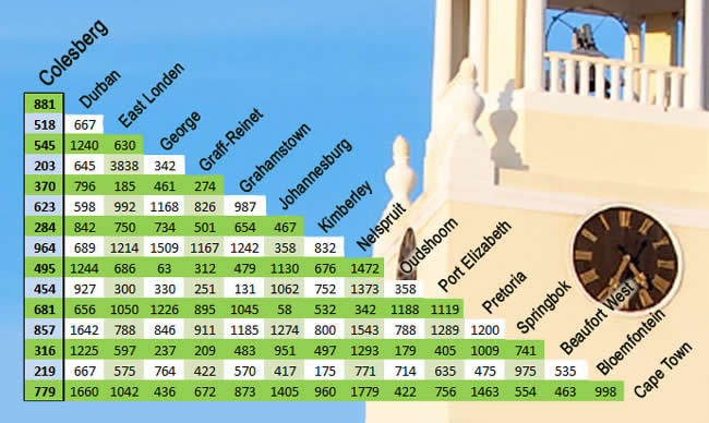
Colesberg is centrally located for overnight accommodation.
If you have information to add please contact us.
Aktiwiteite & vermaak
Geskiedenis
Kaarte
Reis info
NB nommers
Internet Bank
Let wel: Dit is harde werk om al die data op hierdie webwerf akkuraat te hou en dus is dit jou verantwoordelikheid om te bevestig dat die inligting korrek is.
Gebruik al die inligting op hierdie webwerf op eie risiko. As jy inligting het wat opgedateer moet word, kontak ons asseblief onmiddellik.
Foto’s © 2014 deur toerisme fotograaf BerendPhotography.com / webblad & ontwerp deur: eapproach.co.za.